This report outlines county-level flood-risk data and housing statistics for Washington State in light of this month’s devastating flooding. Our hearts go out to Washington residents during this challenging time.
Torrential rainfall that began last week has caused many of Washington State’s rivers to overflow, flooding scores of homes and triggering power outages and mudslides across the state. Over 100,000 people have been advised to evacuate, and Washington Gov. Bob Ferguson has declared a state of emergency. More flooding is expected this week as one major river levee failed on Monday and a second failed on Tuesday. Blizzards and high winds are also in the forecast.
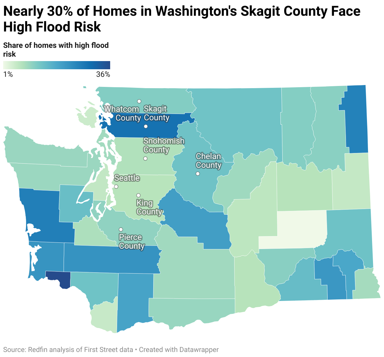
Many of Washington’s 39 counties have either experienced flooding or faced some form of flood warning. Skagit County and Snohomish County, both located north of Seattle, have been hit especially hard.
In Skagit County, 22,810 homes—or 28.6%—face high flood risk, according to a Redfin analysis of First Street data pulled prior to the flooding. That’s the fourth-highest number among the 39 counties in Washington State and the second-highest share. Skagit County has a population of around 130,000.
In Snohomish County, 23,215 homes face high flood risk, the third highest number among the counties in Washington State. That represents 7.6% of homes in Snohomish County, which has a population of about 900,000. This analysis focuses on homes with high flood risk, but it’s worth noting that other homes face risk as well.
“I’ve had a home closing pushed back, showings delayed, and listing appointments rescheduled because of flooding and road closures,” said Don Bleha, a Redfin real estate agent in Snohomish County. “The buyer whose closing got delayed visited the home and the yard was all water. Now he can’t even get there because the highway is closed due to fallen trees and mudslides. People who have considered buying a place in the mountains may be more cautious moving forward—especially those who don’t fully understand how seasonal flooding works in these areas.”
Bleha, who lives on the Skykomish River outside the town of Index, said his yard is flooded and his internet service was out most of last week.
The counties in Washington State with the largest share of homes facing high flood risk according to First Street are Wahkiakum County (35.9%), Skagit County (28.6%), Grays Harbor County (26.2%), Pend Oreille County (25.6%) and Lewis County (22.5%). Many of these counties have grappled with flooding over the past week.
Four of Washington’s 39 counties are considered high-flood-risk counties on a national scale. Redfin defines a high-risk county as one that ranks in the top 10% in the U.S. when it comes to the share of homes facing high flood risk. The counties in Washington State that meet this definition are Wahkiakum County, Skagit County, Grays Harbor County and Pend Oreille County.
The counties in Washington State with the largest number of homes facing high flood risk are King County (41,928), Pierce County (33,097), Snohomish County (23,215), Skagit County (22,810) and Grays Harbor County (15,773), which have all been in the news due to flooding over the past week. Many counties in Oregon have been under flood warnings as well.
Redfin reported last week that homebuyers are more likely to click on climate-risk data when major natural disasters strike, but this urgency is often fleeting. The recent flooding in Washington State is a reminder that it’s becoming increasingly important for homebuyers to consider climate dangers when deciding where to live, and to view natural disasters as an ongoing risk. Here is King County’s guide on how to prepare for flooding, and what to do during and after a flood. Redfin has also compiled relevant resources and links to community organizations here for those impacted by the flooding.
“Flooding happens here every year—the only question is how severe it gets,” Bleha said. “Buyers and sellers must do their due diligence. Don’t rely solely on seller disclosures or a seller saying, ‘It hasn’t flooded for me.’ Ask neighbors, review flood maps, check insurance requirements, and find out whether the home has an elevation certificate. If the home is anywhere near a creek or river, assume you’ll see high water at some point.”
County-Level Housing Market Summary: Washington State
| County in Washington State | Share of homes with high flood risk | Number of homes with high flood risk | Does this county rank as a "high-flood-risk" county nationwide? | Estimated population (2024) | Median sale price (October 2025) | Homes sold (October 2025) |
|---|---|---|---|---|---|---|
| Adams County | 1.4% | 181 | No | 21,039 | $375,000 | 9 |
| Asotin County | 8.8% | 1,155 | No | 22,523 | $305,000 | 14 |
| Benton County | 7.1% | 5,129 | No | 218,190 | $450,000 | 258 |
| Chelan County | 13.9% | 6,398 | No | 81,228 | $570,000 | 106 |
| Clallam County | 9.8% | 5,185 | No | 77,958 | $515,000 | 113 |
| Clark County | 5.5% | 9,527 | No | 527,269 | $541,773 | 542 |
| Columbia County | 21.7% | 1,049 | No | 4,025 | $240,000 | 3 |
| Cowlitz County | 13.8% | 7,574 | No | 113,982 | $419,000 | 115 |
| Douglas County | 9.3% | 2,647 | No | 45,795 | $523,000 | 57 |
| Ferry County | 11.7% | 2,026 | No | 7,543 | $232,500 | 6 |
| Franklin County | 11.3% | 3,687 | No | 101,238 | $449,975 | 76 |
| Garfield County | 18.8% | 702 | No | 2,404 | $299,000 | 3 |
| Grant County | 6.5% | 3,401 | No | 104,717 | $360,000 | 85 |
| Grays Harbor County | 26.2% | 15,773 | Yes | 77,893 | $341,000 | 109 |
| Island County | 9.1% | 4,452 | No | 86,478 | $605,090 | 112 |
| Jefferson County | 9.7% | 3,073 | No | 33,944 | $715,000 | 42 |
| King County | 7.0% | 41,928 | No | 2,340,211 | $899,000 | 2264 |
| Kitsap County | 6.0% | 8,132 | No | 281,420 | $610,280 | 320 |
| Kittitas County | 20.4% | 7,434 | No | 48,172 | $617,500 | 78 |
| Klickitat County | 10.0% | 2,108 | No | 24,124 | $410,000 | 18 |
| Lewis County | 22.5% | 12,344 | No | 87,049 | $447,495 | 92 |
| Lincoln County | 7.1% | 1,554 | No | 11,862 | $551,500 | 6 |
| Mason County | 14.7% | 8,302 | No | 69,632 | $440,000 | 85 |
| Okanogan County | 13.7% | 8,719 | No | 44,942 | $329,000 | 38 |
| Pacific County | 22.3% | 7,343 | No | 24,245 | $342,000 | 24 |
| Pend Oreille County | 25.6% | 4,947 | Yes | 14,332 | $355,000 | 12 |
| Pierce County | 10.7% | 33,097 | No | 941,170 | $568,629 | 880 |
| San Juan County | 5.1% | 871 | No | 18,668 | $754,500 | 21 |
| Skagit County | 28.6% | 22,810 | Yes | 132,736 | $616,000 | 140 |
| Skamania County | 19.5% | 1,609 | No | 12,660 | $432,000 | 9 |
| Snohomish County | 7.6% | 23,215 | No | 864,113 | $737,500 | 804 |
| Spokane County | 5.8% | 11,906 | No | 555,947 | $430,000 | 575 |
| Stevens County | 11.2% | 4,676 | No | 49,015 | $320,000 | 45 |
| Thurston County | 8.0% | 9,049 | No | 302,912 | $535,000 | 325 |
| Wahkiakum County | 35.9% | 1,590 | Yes | 4,800 | $334,500 | 9 |
| Walla Walla County | 15.0% | 4,109 | No | 62,068 | $475,000 | 53 |
| Whatcom County | 11.8% | 12,201 | No | 234,954 | $620,280 | 225 |
| Whitman County | 14.0% | 5,091 | No | 48,399 | $365,000 | 25 |
| Yakima County | 9.2% | 9,292 | No | 258,523 | $367,925 | 200 |
Methodology
Climate risk data comes from First Street, which assigns six different climate-risk categories to properties across the U.S.—minimal, minor, moderate, major, severe and extreme. For this report, a “high-risk” home is one that falls into the major, severe or extreme category for a climate risk. We define a “high-risk” county as one that ranks in the top 10% when it comes to the share of homes facing high risk. That means a high-flood-risk county is one with 23.7%-99.1% of homes facing high risk. Climate-risk scores are based on a property’s current risk as well as how that risk is expected to grow over the next 30 years.